A loop that earns its summit
You can pick out the Ochsenkopf from far away, mostly because of the thin concrete needle of its transmitter tower. At 1,024 m it is the second-highest summit of the Fichtelgebirge, and a well-marked circular walk from the village of Bischofsgrün climbs it in a little under four hours. The walk is called the Weißmain-Ochsenkopf-Steig. The regional tourism board says it became the second certified quality hiking trail of the Ochsenkopf region in 2020, and the Fichtelgebirgsverein hiking club of Bischofsgrün looks after the waymarks.
The route suits walkers who have a decent base fitness but no mountain experience: roughly 430 metres of climbing, no scrambling, and an inn on the summit. It is a poor choice for prams and wheelchairs, and it asks more of children than a lakeside stroll would. What makes it interesting is the order of things. You start in a village valley, follow the upper Weißmain valley to a forest inn, climb past granite rock groups and the spring of the White Main, reach a tower and a mountain restaurant, and drop back to the village along the northern flank.
The track comes from OpenStreetMap, the facts from official tourism, transport and nature park pages, all checked on 16 October 2026. Where sources disagree, the text says so.
Key parameters
- Length: about 10.6 km, measured by us along the OpenStreetMap geometry. The OSM relation itself lists 10.4 km and the tourism board lists 11.1 km. The gap comes from how each source measured the line.
- Time: 3 h 55 min according to the tourism board, without long breaks.
- Climbing: about 435 m up and 433 m down by our calculation from public-domain SRTM elevation data. The tourism board gives 449 m. Treat it as 430 to 450 m.
- Highest and lowest point: the track reaches about 1,019 m near the summit (the summit itself is 1,024 m) and sinks to about 664 m in the valley section. The tourism board lists 1,019 m and 649 m.
- Difficulty: moderate. The tourism board rates it "mäßig" and calls the loop demanding in its trail text. Our reading of the profile agrees: a steady climb of about 330 m over 6.5 km, then a long descent.
- Type: circular, so you finish where you started.
Start and finish
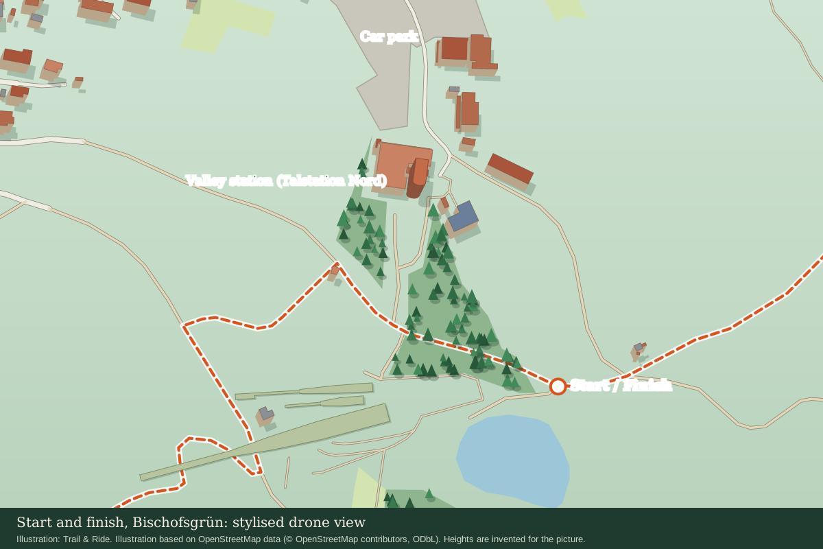
The official starting point is the car park at the north valley station of the Ochsenkopf cable car, address Fröbershammer 27, 95493 Bischofsgrün. The valley station sits at roughly 50.0503° N, 11.8113° E, and the tourism board gives the starting elevation as 694 m. The waymarked loop leaves from a track about 190 m south-east of the station, where the OpenStreetMap route begins (50.0489° N, 11.8129° E). The GPX starts and ends there.
Next to the start you will see the three Ochsenkopf ski jumps, the alpine coaster and the cable car station. OpenStreetMap also maps public toilets and a snack bar (the Liftstube) beside the valley station. Opening times vary.
How to get there
By public transport, two regional bus lines of the VGN network serve Bischofsgrün: line 329 runs Bayreuth, Bad Berneck, Bischofsgrün, Fichtelberg, and line 369 runs Bayreuth, Weidenberg, Warmensteinach, Fichtelberg or Mehlmeisel, Bischofsgrün. The VGN page for these lines (the "Fichtel-Express") puts the journey from Nürnberg main station to Bischofsgrün at about two hours.
For the start, the tourism board names the stop "Talstation Ochsenkopf Nord". In OpenStreetMap the nearest stop is mapped as "Schwebebahn Nord", about 280 m from the track start. The central stop "Rathaus" is roughly 800 m away. A regional tourism site describes line 369 as running hourly on weekdays and every second hour at weekends, with bicycle racks from May to early November, but timetables change with the season and with each December timetable change. Check the VGN journey planner for your date, and check the return bus before you start walking, because the last departures thin out in the evening.
By car, use the paid car park at the north valley station. The tourism board lists 80 spaces and a fee of 2 euros for 24 hours. OpenStreetMap maps a much larger gravel area there, so treat the capacity as a rough figure. The fee comes from the tourism page and may have changed by the time you read this.
Route description
We describe the loop clockwise, because that is the order in which the tourism board lists the stops: Karches, Weißmainfelsen, then the summit, and finally the Hügelfelsen. You can walk it the other way round. Distances below are measured along the OSM line from the start and are good to about 100 m.
Start to Karches (0 to 3.1 km)
The first stretch heads north-east and then south-east along the upper Weißmain valley. The official text names the Naturpfad Oberes Weißmaintal as part of this section. You lose about 20 m in the first kilometre, down to the lowest point of the walk near 664 m, and then the path climbs gently from there to about 750 m near the lake at Karches. Expect forest paths and wider tracks. This is the easiest part of the day and a good warm-up.
At about 3.1 km you reach the Waldrasthaus Karches, a restaurant with a beer garden on the shore of the small Karchessee. The inn describes itself as sitting at the forest edge between the Ochsenkopf and the Schneeberg. The B 303 main road runs past the lake, so the restaurant and the bus stop are the reason to pause here. This is also where you can join or leave the loop: OpenStreetMap shows a bus stop named "Karches Forsthaus" close by. Check the VGN planner for which lines serve it before counting on it. The inn's opening days are not clear from its published pages, so do not plan lunch around it without checking.
Karches to the Weißmainfelsen (3.1 to 4.6 km)
From Karches the path turns uphill on the Goetheweg, a blue and white marked trail of the Fichtelgebirgsverein. According to Wikipedia the Goetheweg was laid out in 1923 to recall Goethe's visit to the Ochsenkopf on 1 July 1785. It climbs steadily for about 1.5 km on a forest path that is narrow in places, with roots and stones along the way. On the way OSM maps a spring, the Rupprechtbrünnlein, at about 3.9 km and 837 m.
The reward is the Weißmainfelsen at about 929 m, a mass of granite blocks on the eastern flank of the Ochsenkopf. The tourism board lists it as a viewpoint and rates the panorama of the whole tour as very high.
Weißmainfelsen to the Weißmain spring (4.6 to 5.1 km)
A short, easy section brings you to the Weißmainquelle at about 900 m, the spring of the White Main. The White Main is the northern headstream of the River Main, which flows on to the Rhine. A few paces away OSM maps picnic benches, a shelter and an information board about springs. It is a good place for a proper rest before the steepest part.
The Fichtelnaab spring is not on the loop, but the tourism board puts it about 800 m south-east of here. It feeds the Naab and so the Danube, which makes the Ochsenkopf a European watershed. An out-and-back adds roughly 1.6 km.
Weißmain spring to the summit (5.1 to 6.5 km)
This is the climb of the day: about 1.4 km that takes you from roughly 900 m to the high point of the track at about 1,019 m. The path is steady rather than punishing. Near the top you pass the Goethefelsen, a viewpoint rock just off the track with an information station about Goethe's visit, and the Ochsenkopf-Wahrzeichenfelsen, the "landmark rock" with a carved ox head. It is one of several explanations offered for the mountain's name, which first appears in a mining deed in the 1490s. Where it really comes from is not settled.
On the summit stands the Asenturm, a stone viewing tower built in 1922 and 1923, with Franconia's highest inn at its foot, the Ochsenkopf Hüttn. According to the local tourism listing, it is open from 9:00 to 18:00, with Monday as the rest day, though a kiosk may open on a fine Monday. The 163 m transmitter tower beside it is not open to visitors. OSM also maps toilets on the summit plateau. The north cable car arrives here too, a gondola line 2,178 m long with a height difference of 359 m, so you meet non-hikers at the top.
Summit to the Hügelfelsen and back to the start (6.5 to 10.6 km)
The descent is long, about 4 km, and mostly pleasant. You pass the Reissingerbrunnen, tagged in OSM as a spring with drinking water, at about 7.2 km, and the Pumperhiebbrunnen shortly after. Do not rely on either as a water source, since there is no confirmation that the water is tested. At about 8.5 km the track passes a hikers' car park on Ochsenkopfstraße, and from here the way becomes a mix of forest tracks and short pieces of quiet residential street at the edge of Bischofsgrün.
At about 9.6 km comes the Hügelfelsen at 745 m, a granite spur on the northern slope that the tourism board lists as a protected natural monument and a geotope. Look from the path and keep off the rock. A shelter named Karl-Bernhard-Hütte stands about 400 m further on, and the loop closes at 10.6 km. The final stretch dips and rises a little, so do not be surprised by a last short climb to the start.
Map and GPX
The route map on this page is generated from the GPX file below. The track is the geometry of OpenStreetMap relation 13710126, which we extracted on 16 October 2026 through the Overpass API. We stitched the ways in order, confirmed that the line closes without gaps, and measured it. Elevations come from the SRTM 30 m dataset, which is in the public domain, queried through the open service opentopodata.org and lightly smoothed. The file also carries eight OSM waypoints for the main stops along the way.
Please treat the file as a planning aid. OpenStreetMap is edited by volunteers, so the line can differ from the waymarks on the ground, and a 30 m elevation model rounds off short steep pitches. For navigation, follow the signs and compare with the official tour page of the tourism board, which offers its own GPX download and an info PDF. The geometry is © OpenStreetMap contributors and available under the Open Database Licence (ODbL), so keep that credit if you share the file.
Seasonal conditions and safety
The tourism board states that the trail is freely accessible at any time. No month-by-month rating is given. As a rule of thumb for this route, late spring to early autumn is the simplest window, which is a judgement rather than an official statement.
Plan for the height. The summit is about 330 m above the start, and it is usually cooler, windier and cloudier up there than in Bischofsgrün. Fog can hide the waymarks, so carry a map or a track that works offline. Granite and roots turn slick when wet, especially on the Goetheweg climb and on the rocks at the Weißmainfelsen and Hügelfelsen. In winter, expect snow or ice on the upper half. The certified winter trail in this area is the Ochsenkopfrunde, not this one, so bring microspikes or choose that route instead. In a thunderstorm, stay away from the Asenturm and from open rock. The European emergency number is 112.
Allow time. The official 3 h 55 min assumes no long stops. With a rest at the spring and lunch on the summit, plan on five to six hours (our estimate) and finish before dusk.
Practical recommendations
- Water: carry at least 1 to 1.5 litres. The refreshment stops are the Waldrasthaus Karches at about 3.1 km and the Hüttn at the summit; the springs on the map are untested.
- Footwear: sturdy shoes with a grippy sole. Trail runners are fine in dry weather, but boots help on the wet root sections and on the descent.
- Accessibility: not suitable for strollers or wheelchairs. The route has roots, stones and a sustained climb. The tourism pages list the Hüttn as suitable for strollers and the car park as accessible, so a shorter visit to the summit by cable car works for mixed groups.
- Dogs: the tourism board lists the route as dog-friendly. Keep dogs close and on a lead near other walkers and wildlife.
- Rules: the loop lies inside the Naturpark Fichtelgebirge. Stay on marked paths, take your litter with you, and leave rocks and the protected Hügelfelsen alone. The summit area is a natural monument, as an information board there shows.
- Shortcuts and alternatives: ride the north cable car up or down to skip most of the climb, or join and leave at Karches by bus if the timetable fits. For a longer day, the regional tourism site lists a 22.5 km Schneeberg and Ochsenkopf tour that includes the Weißmain-Ochsenkopf-Steig as one section (details).
Sources and verification date
All checks were made on 16 October 2026. Opening hours, fees and timetables change, so confirm them before you travel.
- Route geometry: OpenStreetMap relation 13710126, data under the ODbL, © OpenStreetMap contributors.
- Elevation: SRTM 30 m through opentopodata.org.
- Official tour page with length, time, ascent, car park, bus lines and highlights: Fichtelgebirge regional tourism.
- Certification and trail overview: ErlebnisRegion Fichtelgebirge, hiking trails.
- Buses 329 and 369: VGN Fichtel-Express; bus frequency note: Erlebnis Ochsenkopf.
- Cable car data: Ochsenkopf ropeways.
- Summit inn: Ochsenkopf Hüttn am Asenturm.
- Karches inn: Waldrasthaus Karches.
- Asenturm and mountain: Naturpark Fichtelgebirge, Ochsenkopf and Wikipedia: Ochsenkopf.
- Goetheweg: Wikipedia: Goetheweg.
Related content
If you like forested low mountains that you can reach by public transport, the spring walk from Vienna into the Wienerwald covers a similar kind of day in Austria.